People that like trains, abandoned places, or Maine history will appreciate the abandoned ghost trains of Maine. They’re deep in the north woods and are not exactly easy to get to, but the ride itself is part of the journey.
This article describes my trip there and will (hopefully) encourage you to visit this unique destination as well. Be forewarned, however. Getting there isn’t easy. In fact, it can be downright confusing. But with a little planning, and the printable directions I’ve included here, you can get there – and back again – safely.
A Brief History of the Locomotives
Maine is about 90% forested, the most of any state. That includes the roughly 12 million acres of working forestland that make up the north woods of Maine. Maine’s history with working these forests goes back since its early settlement.
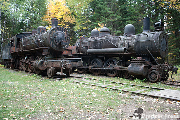
There were two railroads working in the Maine lumber industry from 1927-1933 in the area from around these trains, The Eagle Lake and West Branch. We may be accustomed to thinking of trains being built to carry goods and people across long tracts of open land, but in this case their lines were carved through the forest to haul logs out of the woods.
On average, it’s reported that the 12 cars these trains hauled carried more than 6,500 cords of wood across their tracks.
The trains were purchased used by Edouard LaCroix and brought wood for paper-making, mainly for Great Northern Paper. When they were moved to the north woods they were converted from running on coal to running on oil, a wise move to reduce the chances of accidental forest fires.
Operations ended in 1933, and by that time the trains were too old and obsolete to justify bringing them out of the woods for resale. The easiest thing to do was leave them where they stood, parked inside a shed. That shed burned down in 1966 and the trains began to rust. To prevent their complete destruction by the elements, the trains were painted in 1969.
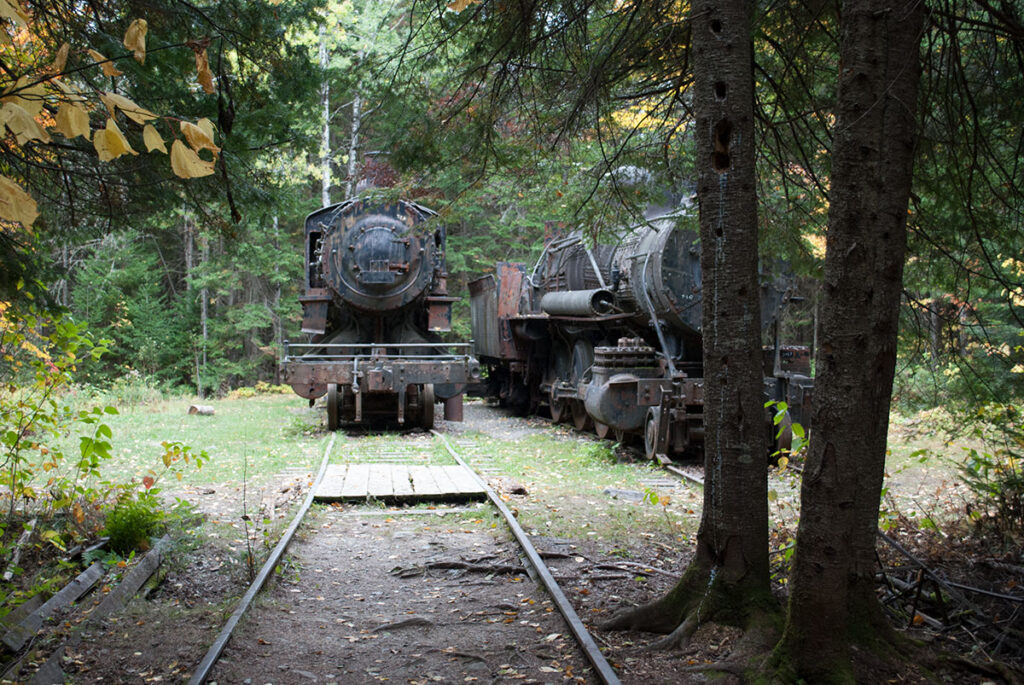
Though it is now just a collection of rusty parts strewn through a remote forest, the Eagle Lake Tramway is one of the most fascinating examples of Maine ingenuity. Devised more than a century ago to transport logs from one lake to another, this steam-powered mechanical system is remarkable testimony to old-fashioned know-how and a willingness to take on any problem.
https://www.maine.gov/dacf/parks/discover_history_explore_nature/history/allagash/tram.shtml
One of Maine’s Abandoned Places
There aren’t many places where you can be miles away from civilization and come upon abandoned steam locomotives, but deep in the North Woods of Maine, near Eagle Lake, you can find them… if you know how to get there.
How to Get to the Abandoned Trains from Greenville/Kokadjo
Getting there is half the fun, but if you have never ventured deep into Maine’s woods before, you’ll quickly realize this is not a typical road trip. The roads are entirely unpaved, there are no gas stations, no convenience stores, no homes, and very few road signs. You can drive for hours and not see another vehicle!
You can approach the trains from a few directions in the state. We made our trip from Kokadjo, a very small spot north of Greenville where the pavement ends and the dirt roads begin.
I created a PDF document that contains the directions that you can download and print below.
Download Directions to Abandoned Trains of Maine
Use these directions at your own risk. Make sure you have made reasonable preparations for the trip. It is miles upon miles from emergency services.
Note that most of the driving will be on gravel logging roads. You cannot, and should not, expect a smooth drive. In addition to washouts, ruts, and confusing roads with few to no signs, broken shale on the roads cuts holes in tires all the time. Also watch out for moose, deer, and large logging trucks going at high speed. Lastly, there is no cellphone reception.
Drive north from Greenville to Kokadjo on Lily Bay Road, and then…
- Upon the pavement ending, you will see a sign that says Weyerhaeuser. Veer LEFT onto Silas Hill Road.
- Stay STRAIGHT on main road, not toward Spencer Pond / Spencer Bay Road.
- You’ll come to a sign that says Medawisa Lodge and Cabins/Smithtown Road. Do not take that right. Instead, stay LEFT/on the main road.
- Continue straight until you come to an NLC sign and a fork in the road. Stay STRAIGHT here, do not go to the left of the fork.
- Continue driving until you come to tall yellow pillars. Drive through the pillars. Just one more gateway bringing you deeper and deeper into the North Woods of Maine!
- About a mile later, you’ll see an NLC sign – stay STRAIGHT here.
- A little under a mile after that, stay RIGHT at the fork.
- Drive straight until you come to one-lane bridge; go over the bridge.
- Continue going forward PAST the sign to Big Spencer Mountain Trail.
- Drive straight, PAST a sign for Ragged Riders / Ragged Lake Campground on your left.
- Continue on, going over another one-lane bridge.
- You’ll see a Stop Ahead sign. Continue forward to the sign, which is where the road comes to an end.
- Take a RIGHT at the Stop sign – you are now on the infamous Golden Road. There will be no sign that you’re on the Golden Road – just trust us.
- Soon you should see pavement. You’ll drive past Chesuncook Lake (on left), and will see a “beach” of driftwood.
- Road becomes a combination of pavement and dirt. Keep going!
- Drive PAST the Allagash Gateway Camps sign.
- Continue forward, and soon you’ll see power lines!
- WORTH STOPPING FOR: Near the power lines, you will see an area where you can park and walk a little trail down to the water and see the Ripogenus Gorge. It’s beautiful and a great place to stretch your legs and take some pictures.
- Once you’re back in the car, continue going until the road divides. This is almost immediately after the gorge. Here, take the LEFT onto Telos Road.
- Continue driving for a bit. You’ll pass a gravel pit and then see Soubunge Mountain on your left.
- Soon, you will reach the TELOS CHECKPOINT. You must stop here and register your personal information and pay ($10 per person). At this point, you’re about half way through your trip. From here, the locomotives are a mere 30 miles away!
- After departing the checkpoint, continue driving straight and eventually you’ll reach the Chamberlain parking lot, where the road comes to a T. Take a LEFT here onto Umbazookus Road.
- Follow this road for about eight miles. You’ll come to an intersection of Guy Allen Road and Grande Marche Road (aka “Trans Canada”). Bear RIGHT here.
- After about another eight miles, you’ll come to a 3-way intersection. Stay RIGHT here, onto Edmond Roy Road (toward Loon Lodge).
- Continue on, going over a small wooden bridge.
- At next intersection, you’ll see signs for Loon Lodge directing you left. Stay STRAIGHT here.
- Continue driving, go PAST Chamberlain Lake Road on your right.
- Soon, you’ll drive past a bunch of logging camps.
- Continue forward, and you’ll come to a wooden bridge. Go over bridge and now you’re only about a mile from your destination!
- Soon, you will see a dirt/gravel road on your right and signs for Tramway Road. Take that RIGHT.
- Follow road for about a mile until you see a sign on your left directing you to turn RIGHT to the Tramway.
- You’ll know you’ve arrived when you come to a parking lot complete with an outhouse! Park here, look for entrance to walking trail.
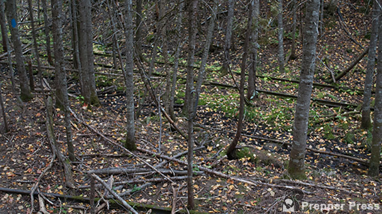
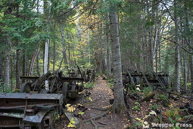
There are quite a few interesting spots along the walking trail, which is relatively flat and well maintained. It took us 20-30 minutes to walk from the parking area to the locomotives. The two locomotives sit in a clearing.
After you’ve spent some time staring at them in awe and taking photos, be sure to go a little farther toward the water just so you can enjoy the beautiful setting before starting back on your journey home.
Words of Warning
There are some words of caution before you make your spooky trip to the ghost trains in Maine.
- First – If you use our directions, you use them at your own risk. Make sure you are prepared. This is not a typical drive.
- Second – You’ll be driving on miles upon miles of dirt logging roads. The broken shale on the roads has been known to slash through tires. Getting a flat tire is not uncommon.
- Third – You will be going into remote wilderness where few people travel. Moose and deer walk these roads, so watch out.
- Fourth – There are hardly any road signs to direct you, so don’t expect to see many. There is no cellphone reception, either.
What to Bring with You
There are some things you’ll want to bring along – for safety’s sake. Following are my recommendations:
- Maine DeLorme Atlas – It won’t be of the best help once you’re in the North Woods, but it won’t hurt, either. All of the pages are topographical maps which can help you orient if you’re lost.

- Amazingly detailed and beautifully crafted, large-format paper maps for all 50 states
- Topographic maps with elevation contours, major highways and roads, dirt roads, trails and land use data
- Gazetteer section contains information essential for any outdoor enthusiast, such as points of interest, landmarks, campgrounds, golf courses, historic sites, scenic drive recommendations and more...
- Perfect for sightseeing, exploring back roads, outdoor recreation and trip planning
- Compass – This can be used with the topographical maps in the atlas above – should the unexpected happen.
- Handheld GPS – A GPS will help you know where you are. It can track your trip. Our downloadable directions also include coordinates.
- First Aid Kit – This can’t be understated.
- Extra Gas – There are no gas stations nearby. If you go off course, having extra gas on hand will bring peace of mind.
- Tire Repair Kit – I once went on a trip to the North Woods where a friend got a flat and had to replace the tire, got another flat and used my repair kit, then got a third flat and had to use duct tape and glue to fill the hole (it worked!).
- Small Air Compressor – A flat tire won’t fill itself.
- Jumper Cables – You don’t want to find out your battery died three hours away from civilization.
- Emergency Survival Food – This stuff lasts forever, so you can pack it and forget it. Make sure you have a hiking stove to go with it.
- Water – Bring enough drinking water for everyone in your party and/or a means to purify water. Bring extra water if you plan to cook some of that emergency survival food.
Abandoned Ghost Trains Summary
Beyond that, download our directions, watch the video, allow yourself plenty of time for the trip, and tell someone where you’re going!
Have you been to the ghost trains or other abandoned places? We’d love to hear about it in the comments.